What do you think “Which Mapping Platform Is Best in 2025: Mappls (MapMyIndia) or Google Maps or OpenStreetMap?”
In the automotive OEM (Original Equipment Manufacturer) space, MapmyIndia dominates with a market share of around 80-90%. However, for consumer-end navigation, Google Maps is the dominant player, especially among Android users.
In today’s competitive business landscape, where efficiency, visibility, and real-time data drive success, digital maps have evolved from simple navigation tools to essential business enablers. Whether you’re managing last-mile deliveries, tracking on-ground field agents, or helping customers find your nearest store, selecting the right digital map platform can dramatically enhance your operational precision.
Navigating business challenges often requires innovative solutions, and more often than not, maps emerge as powerful tools to chart success. Whether it’s listing store locations or monitoring the on-ground activities of your sales force, maps offer a plethora of solutions that can elevate your business to new heights. In this blog, we deep dive into MapmyIndia vs Google Maps vs OpenStreetMap and help you select the best digital map vendors based on their features, accuracy, and use case fit.
In this detailed 2025 guide, we compare MapMyIndia, Google Maps and OpenStreetMap, three leading digital mapping providers, to help you choose the best-fit solution for your business needs based on features, cost, data accuracy, interface, API support and user trust.
Overview of the Best & Leading Mapping Platforms in 2025:
Mappls (MapMyIndia) vs Google Maps vs OpenStreetMap
In the ever-evolving world of digital infrastructure, mapping technologies have become mission-critical for everything from logistics and mobility to smart cities and emergency services. Whether you’re building an app, optimizing delivery routes or integrating geospatial analytics into your operations, the right mapping platform can significantly impact your success.
Let’s explore the three most prominent players in the mapping space in 2025:
MapMyIndia (Mappls), Google Maps Platform and OpenStreetMap (OSM) each catering to unique business needs and market preferences.
1. MapMyIndia (Now Mappls): India’s Indigenous Mapping Leader
Founded in 1995, MapMyIndia, rebranded as Mappls, has emerged as India’s foremost homegrown digital mapping and geospatial data platform. Over nearly three decades, it has built a comprehensive stack of technologies tailored specifically for Indian terrain, infrastructure, and regulatory needs.
As of 2025, Mappls offers:
- Highly detailed and hyperlocal maps of India’s urban and rural areas, including 3D landmarks, speed breakers, tolls, potholes, and safety zones
- Real-time navigation and telematics services used extensively in electric vehicles, logistics fleets, and law enforcement
- Developer-friendly APIs and SDKs for Maps, Routing, Geofencing, Geotagging, Navigation, and Live Tracking
- AI-powered spatial analytics integrated with satellite imagery, IoT sensors, and drone data
With strategic collaborations across automotive, fintech, retail, and government sectors, Mappls has become the go-to choice for India-first enterprises seeking precision, compliance, and localization.
MapMyIndia (Now Mappls) Best suited for:
Businesses operating primarily in India that need granular, regulation-friendly, and hyperlocal mapping intelligence.
2. Google Maps Platform: Global Giant with Scalable Intelligence
As of 2025, Google Maps Platform powers over 5 million active apps and websites and maintains its dominance with a presence in 220+ countries and territories. With more than a billion monthly users, it remains the most familiar and widely trusted digital mapping solution globally.
Key highlights of Google Maps in 2025:
- Maps, Routes, Places, and Environment APIs, now enhanced with Gen AI-powered contextual search and augmented reality (AR) overlays
- New environmental datasets such as air quality forecasts, solar potential, tree canopy coverage, and flood zone prediction
- Seamless integration with Google Cloud, Android Automotive, and major CRMs, enabling deep product and user experience personalization
- Updated pricing structure in India with up to 70% cost reduction and ONDC-focused subsidies for government-linked platforms
Its intuitive UI, robust reliability, and deep developer support make it the top choice for businesses scaling globally or requiring premium features like dynamic routing, immersive street view, and predictive traffic analysis.
Google Maps Best suited for:
Enterprises needing global scalability, real-time precision, and integration with Google’s broader ecosystem.
3. OpenStreetMap (OSM): The Open-Source Backbone of Global Mapping
Created in 2004, OpenStreetMap (OSM) is a crowdsourced, community-driven mapping project known for its transparency, accessibility, and customization capabilities. It thrives on the contributions of millions of mappers worldwide who collect and upload data daily.
In 2025, OpenStreetMap stands out with:
- Editable, raw geographic data ideal for building bespoke geospatial applications
- Complete freedom from commercial licenses, making it a powerful option for startups, research institutions, and humanitarian agencies
- Compatibility with open-source mapping libraries and visualization tools like Leaflet.js, Mapbox, OSMnx, and QGIS
- Used by organizations like Meta, Microsoft, Amazon, and Humanitarian OpenStreetMap Team (HOTOSM) to build internal tools, humanitarian maps, and offline applications
While OSM’s base platform lacks the polish of commercial competitors, its strength lies in flexibility, cost-efficiency and the power of global collaboration. It’s especially useful for remote or underserved areas where major providers may lag.
OpenStreetMap Best suited for:
Tech-savvy teams looking for full control, budget-conscious projects, and open-source-centric geospatial development.
Tatvic’s Case Snippet: Optimizing Delivery Routes for a Hyperlocal Grocery Brand using Google Maps API
Client: Leading Hyperlocal Grocery Chain in Tier 1 & Tier 2 Cities
Challenge: Inefficient last-mile delivery due to inaccurate location clustering and lack of real-time traffic insights.Tatvic’s Solution:
- Implemented Google Maps Directions API with live traffic overlays
- Integrated Geocoding API for accurate pin-to-door navigation
- Built a custom dashboard to monitor delivery ETAs and rerouting triggers
Outcome:
- 23% reduction in delivery time
- 17% improvement in customer satisfaction score (CSAT)
- ₹8.6L annual cost savings via route optimization
Mappls (MapMyIndia) vs Google Maps vs OpenStreetMap: 2025 Detailed Comparison Table
Choosing the right mapping platform can significantly influence your product performance, cost-efficiency, and user experience.
This side-by-side comparison evaluates MapMyIndia (Mappls), Google Maps, and OpenStreetMap (OSM) across critical parameters to help you decide the best fit for your business in 2025.
The Major Differences: MapMyIndia vs Google Maps vs OpenStreetMap
Feature |
MapMyIndia (Mappls) |
Google Maps Platform |
OpenStreetMap (OSM) |
|---|---|---|---|
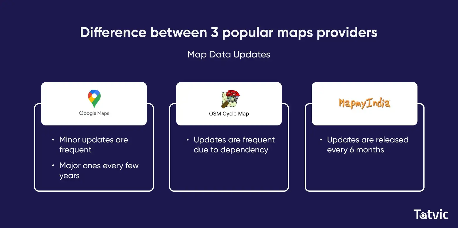
Map Data Updates |
Updates every 6 months with a focus on local details like road conditions, real-time traffic monitoring updates, and unsafe road information. | Real-time global updates powered by AI, user feedback, and satellite data. | Relies on community updates, leading to frequent and agile changes. However, updates can be uneven globally due to reliance on users. |
User Interface (UI) |
Busy interface with rich local details, similar in look and feel to Google Maps. Ideal for operations requiring detailed information in India. | Clean, precise, and user-friendly. Two different map types with details like terrain, transit, and traffic. Best suited for a diverse audience and various use cases worldwide. | A simpler interface is less granular compared to others and is more suited for basic navigation needs. |
APIs & SDKs |
Mapping APIs: Includes API’s for Maps, Search and geocoding, Routes and navigation, Route planning and optimization.
Analytics APIs: Includes APIs for GIS and Analytics APIs Telematics APIs: Includes API’s for Mobility and tracking, Workmate APIs. |
Maps: Includes APIs for Aerial view, Dynamic maps, Dynamic street maps, Elevation, Map tiles, Map Datasets, Maps Embed, and Static Street View.
Routes: Includes APIs for Directions, Direction matrix, Roads, Compute routes, and Compute routes matrix. Places: Includes APIs for Address validation, Autocomplete (automatic suggestion of places), Current place, Geocoding, Geolocation, Nearby search, Place details, Place photos, Text search, and Time zone. Environment: Includes APIs for Air quality mapping, Pollen mapping, Solar mapping |
Overpass API: Powerful query language for retrieving OpenStreetMap data based on geographical criteria and custom filters. Used for downloading map data, finding specific features, and analyzing spatial relationships.
Nominatim API: Geocoding service that converts addresses into geographical coordinates (latitude and longitude) and vice versa. Others: Several community-developed APIs exist for specific purposes like rendering maps (Leaflet, |
~Cost (As in 2025) |
Offers a free tier for individual users with limited features. Paid plans range from $302/month for 10,000 API calls to $605/month for 50,000 API calls (as per one source). | In July 2024, Google has announced a 70% reduction in cost for Maps for India. Additionally, for ONDC projects, up to 90% discounts are available on selected APIs. This makes Google Maps the most competitive in terms of price against the features it offers. | Free to use as it’s community-driven. Costs may be associated with third-party APIs built on top of OpenStreetMaps. |
Notable Users |
Notable brands like McDonald’s India, Maruti Suzuki, Mahindra, Ather Energy and PhonePe. Ideal for companies focusing on the Indian market. | Used by a range of businesses globally, including Swiggy, Zomato, Uber, Amazon, Ola, Dunzo and MakeMyTrip in India. Suitable for businesses with global presence or high-volume usage. |
Employed by Meta, Red Cross, HOTOSM, Craigslist. Popular among cyclists, hikers, and mountaineers for specialized maps (e.g., OpenCycleMap). |
Developer Support |
Localized documentation and onboarding, India-based tech support. | Robust SDKs, forums, and documentation via Google Cloud Console. | Community-powered support via forums, wikis, and GitHub repos. |
Best Suited For |
Best suited for operations that focus solely on Indian map applications and need rich local details.
India-focused companies needing hyperlocal intelligence and regulatory alignment. Not ideal for global expansion in the short term.
|
Industry leader with a global reach and comprehensive functionality. Ideal for new-age or traditional businesses seeking an easy-to-adapt platform with global adaptability.
|
Suitable for businesses with stringent budget considerations or proponents of open-source technology, but requires more development efforts for complete functionality. |
We have seen a quick comparison among of the Best & Leading Mapping Platforms in 2025 in tabular format. Now Let’s see the comparison in depth->>
Mappls (MapMyIndia) vs Google Maps vs OpenStreetMap: Feature by Feature Detailed Comparison
1. Map Data Accuracy and Updates
Why It Matters:
Accurate and up-to-date mapping data is non-negotiable in today’s fast-paced, hyperconnected economy. Whether you’re navigating urban traffic, planning last-mile deliveries, or deploying on-ground teams, outdated maps can lead to costly detours, missed SLAs, and dissatisfied customers. In 2025, where digital maps power everything from EV routing to drone logistics, the frequency and precision of updates are mission-critical.
MapMyIndia (Mappls): Hyperlocal Accuracy for India:
MapMyIndia, now branded as Mappls, stands out for its deep focus on Indian geospatial nuances. Updated twice a year, the platform offers hyperlocal intelligence including:
- Real-time road hazard alerts (potholes, speed breakers, waterlogging)
- Safety markers like accident-prone zones and illegal U-turns
- Granular address-level data with detailed landmark tagging
- Integration with government sources like MoRTH and Smart City initiatives
In 2025, Mappls also supports EV route optimization and detailed village-level mapping under the Digital India initiative. It’s a go-to for logistics firms, delivery apps, and fleet operators who need precision in Tier 2/3 cities and rural belts.
MapMyIndia (Mappls) is Best for:
India-focused businesses that need regulatory-compliant, real-world mapping fidelity.
Google Maps: Global Data, Real-Time Intelligence
Google Maps continues to dominate on a global scale with daily updates derived from:
- High-resolution satellite imagery
- Street View fleets and drones
- Crowdsourced data from 1B+ Android devices
- AI-powered traffic and construction detection
As of 2025, Google Maps also integrates AI-generated 3D maps, climate overlays (like air quality, pollen, solar energy zones), and environmental impact data, making it invaluable for businesses operating across geographies.
Google Maps is Best for:
Scalable global operations, ride-hailing platforms, and companies needing up-to-the-minute data across multiple regions.
OpenStreetMap (OSM): Open-Source Mapping With Grassroots Power
OpenStreetMap thrives on its volunteer-driven model, offering highly frequent updates in areas with active contributors. It supports:
- Editable map layers for custom deployments
- Community-verified POIs and trails
- Extensive tagging options for niche use cases (e.g., wheelchair access, hiking paths)
While it shines in urban centers with engaged mappers, data consistency can vary in remote or underdeveloped regions. However, in 2025, the rise of humanitarian organizations and open-data initiatives has greatly improved coverage in Africa, Southeast Asia, and remote India.
OpenStreetMap (OSM) is Best for:
Nonprofits, civic tech developers, GIS researchers, and startups favoring low-cost, customizable, and ethical solutions.
Tatvic Case Study 2: MapMyIndia Integration for an Indian EV Manufacturer
Client: Fast-growing EV two-wheeler brand in India
Challenge: Google Maps failed to provide detailed POI data in non-metro towns where charging stations were placed.Tatvic’s Solution:
- Switched to MapMyIndia’s location APIs with rural coverage
- Deployed reverse geocoding to align location tags with charging infrastructure
- Enabled real-time tracking with MapMyIndia Telematics API
Outcome:
- 32% increase in charging station visibility
- 41% reduction in customer support tickets related to location errors
- Enhanced brand credibility in under-served regions
2. User Interface and Experience
Why It Matters:
In 2025, the user interface (UI) and overall experience (UX) of a mapping platform aren’t just cosmetic—they’re strategic. A well-designed UI enhances productivity, reduces training time for internal teams, and creates a seamless experience for end-users across logistics, e-commerce, real estate, mobility, and field operations. As maps become embedded into core business workflows, a platform’s usability directly influences adoption rates, decision-making speed, and customer satisfaction.
Google Maps Platform: Enterprise-Grade UI with Consumer Simplicity
Google Maps remains the gold standard in UI/UX. With a clean, clutter-free interface and lightning-fast load times, it provides fluid zooming, dynamic layer toggling, and intuitive controls across devices.
With over 3.6 billion Android smartphones worldwide, GoogleMaps stands out as having the best interface. The extensive user base gives Google the credibility of having an interface that is well-received by a diverse audience with various use cases. At first glance, the interface of Google Maps is clean, precise, and user-friendly. Featuring two different map types, with multiple map details like terrain, transit, traffic, and more, it allows a user to navigate based on their requirements.
As of 2025, its advanced rendering includes:
- Immersive View: Realistic 3D environments for key landmarks and urban areas
- Live Transit & Traffic Layers: Real-time overlays for buses, metros, traffic congestion, and alternate routes
- Personalized Maps: AI-curated suggestions based on user behavior and preferences
- Responsive Design: Optimized for mobile, desktop, AR, and even in-car navigation units
This makes Google Maps a go-to choice for B2C and B2B applications where aesthetics, real-time accuracy, and frictionless UX matter most.

Google Maps is Best For:
Businesses prioritizing a polished, ready-to-deploy mapping UI with global consistency
MapMyIndia (Mappls): Localized Intelligence in a Familiar Format
MapMyIndia has significantly upgraded its UI as part of its Mappls brand evolution. Designed with India’s unique navigation challenges in mind, it blends familiarity (resembling Google Maps in layout) with enriched, hyper-local insights:
- Localized Layers: Speed breakers, potholes, no-parking zones, electric vehicle charging stations
- Voice Navigation in Indian Languages: Supports 10+ languages, crucial for field teams and delivery agents
- Region-Specific Icons and Labels: Clearly marked landmarks and street-level nuances rarely captured by global platforms
- Traffic and Safety Widgets: Integrated road hazard alerts and smart traffic predictions using IoT signals
It’s ideal for enterprises operating in Indian metros, tier-2/3 cities, and rural regions where local detail can mean the difference between operational success and failure.

MapMyIndia is Best For:
Indian enterprises needing localized, granular map interfaces with regional language support
OpenStreetMap (OSM): Customizable Canvas for Developers and Innovators
OpenStreetMap’s UI is intentionally minimal, making it more of a starting point than a finished product. What it lacks in visual refinement, it makes up for with flexibility:
- Open-Source Frontends: Leverage tools like Leaflet, MapLibre, or custom renderers to build tailored UIs
- Editable Layers: Users can add or remove features, roads, or landmarks in near real-time
- Community Tools: Projects like OpenCycleMap or Humanitarian OpenStreetMap offer themed visual layers for specific use cases
- Offline Capabilities: Easy integration with offline apps for disaster zones, remote areas, and NGOs
For startups, civic tech, humanitarian efforts, or cost-sensitive enterprises with in-house tech talent, OSM offers a unique canvas to build completely custom mapping experiences.

OpenStreetMap (OSM) is Best For:
Organizations seeking full control over map UI/UX or building niche, open-source mapping solutions
3. API & Developer Ecosystem
While incorporating maps in your mobile app or website, it is important to select the platform with the right APIs and SDKs. This helps you to fetch the features of those platforms into your app or website and make the experience more intriguing for your users.
Why It Matters:
In 2025, APIs form the backbone of modern mapping solutions, empowering developers to seamlessly integrate, customize, and extend location services within apps and platforms. From real-time tracking and geofencing to advanced spatial analytics and immersive AR experiences, a rich API ecosystem accelerates innovation and improves operational efficiency.
OpenStreetMap APIs & Tools:
- Overpass API enables highly customizable queries for tailored data extraction
- Nominatim provides free, open-source geocoding and reverse-geocoding services
- Integration with third-party open-source tools such as Leaflet, Mapbox, and OSMnx for map rendering, interactivity, and routing flexibility
- Ideal for developers seeking full control and adaptability without licensing constraints
OpenStreetMap (OSM) is Best For:
For open-source enthusiasts and projects that require customizable, cost-effective mapping solutions with hands-on developer involvement.
If you are working on stringent budget considerations or are a proponent of open-source technologies, then you can consider OpenStreetMaps. However, this entails more development efforts to achieve complete functionality.

Google Maps Platform: APIs & Tools:
- Cutting-edge Augmented Reality (AR) and AI-driven mapping features enabling immersive user experiences
- Environment-focused APIs including Solar Mapping, Pollen Index, and Air Quality Data to support sustainable decisions
- Advanced Place Intelligence APIs offering sentiment analysis, user activity heatmaps, and dynamic place details for rich contextual insights
- Well-documented, scalable APIs designed for global enterprises with diverse use cases
Google Maps is Best For:
For plug-and-play, enterprise-grade APIs backed by extensive documentation and innovation.
Using Google Maps for your apps and websites would be the easiest choice since it’s hassle-free and is an industry leader. Its established reputation and technical reliability make it particularly appealing for businesses with an established presence or anticipating high-volume usage in the future. Furthermore, Google Maps offers the most comprehensive functionality in this domain.

(Note: If you want to know how to get the Google Maps API key, then click to view this blog.)
MapMyIndia API Suite Includes:
- Comprehensive Maps, Geocoding, and Search APIs tailored for Indian geographies
- Advanced Route Optimization for logistics and last-mile delivery
- Real-time Vehicle Tracking and Fleet Telematics for enhanced operational control
- Powerful GIS Analytics supporting location intelligence and business insights
MapMyIndia is Best For:
If you focus solely on the Indian map applications and have no plans to expand overseas shortly, considering MapMyIndia APIs for your websites and apps with robust analytics could be a strategic move.

Tatvic Case Study 3: Using OpenStreetMap for a Social Impact Project
Client: International NGO operating in flood-prone zones
Challenge: Need for accurate, editable maps to deploy emergency aid in remote districts of AssamTatvic’s Solution:
- Used OpenStreetMap with Overpass API and Leaflet.js for a custom flood alert map
- Integrated with community-generated data layers and predictive rainfall APIs
- Trained field volunteers to update map layers in real-time using OSM tools
Outcome
- 100+ new POIs (evacuation shelters, medical camps) added within 3 weeks
- Reduced data dependency on third-party vendors
- Real-time local updates improved aid distribution by 28%
4. Cost and Licensing (2025 Updates)
Balancing functionality with affordability is critical in 2025, especially as apps scale and location data usage grows exponentially. Choosing the right mapping platform means understanding not just base costs, but hidden licensing terms, scalability options, and long-term ROI. Here’s how Google Maps, MapMyIndia, and OpenStreetMap compare on cost and licensing.
Why It Matters:
In 2025, cost efficiency is as crucial as functionality, especially for scaling startups, mobility platforms, logistics operations, and enterprise applications handling millions of API calls monthly. Choosing a location platform that fits your budget without compromising on features can lead to significant long-term savings and predictable ROI.
Perhaps in this comparison of MapMyIndia v/s Google Maps v/s OpenstreetMaps, the cost is the most important decision when it comes to selecting the right map platform. Most map platforms have a certain threshold of free usage of the APIs, and if your usage goes beyond that, you are required to pay. While assessing the price, make sure that the API is effectively addressing the specific requirements of your project as well.
Tip: Selecting the correct APIs and optimizing them can help you reduce your cost. For more details, consult with our team.
Google Maps Platform (2025 Pricing Advantage):
Google significantly revamped its pricing structure in 2024, making its platform far more affordable in India and emerging markets.
With Google Maps, the free tier includes 28,500 map loads per month worth $200 for static maps and basic functionalities. For higher usage or advanced features, Google Maps API pricing starts at around $7 per 1,000 API calls and can go up to $16 or more for specific features. You can also estimate your monthly cost based on your Google Maps usage from here.
- Up to 70% reduced pricing in India for commercial users
- 90%+ discounts for ONDC-aligned businesses, startups under DPIIT, and government-linked platforms
- $200 free monthly credit, which translates to approximately 28,000 static map loads or equivalent API usage
- Flexible pay-as-you-go billing model with usage-based scalability
- Ideal for companies needing enterprise-grade reliability at competitive cost
Google Maps Platform is Best For:
Best for scalable, global applications with rich features and dynamic pricing
MapMyIndia (Mappls) Pricing (2025):
Focused on the Indian market, MapMyIndia offers transparent and region-specific pricing.
Working on a similar model to Google Maps, MapMyIndia offers a free tier for individual users with limited features. It includes basic functions like navigation and search. Although not available publicly, as per one source, paid plans range from $302 per month for 10,000 API calls to $605 per month for 50,000 API calls.
- Plans start at ₹25,000/month (~$300) for 10,000 API calls
- Enterprise-grade solutions come with custom pricing, white-label options, and SLA-based support
- Offers fixed billing cycles, great for organizations looking to budget precisely with no usage surprises
- API bundles often include tracking, analytics, and vehicle telematics tailored to Indian terrains and routes
MapMyIndia is Best For:
Optimal for businesses operating in India that need hyper-local data and fixed, predictable billing
OpenStreetMap (OSM) – The Free & Open-Source Choice:
Being an open-source platform, OpenStreetMaps is free to use as it is community-driven. However, if you are using third-party APIs built on top of OpenStreetMaps, it might have its pricing structure.
- Completely free to use under the Open Database License (ODbL)
- No direct licensing costs, but businesses may incur fees for integration, hosting, or enhanced capabilities from third-party services like Mapbox, CARTO, or GraphHopper
- Ideal for developers and non-profits looking for unrestricted access to geospatial data
- No usage quotas or API call limits when self-hosting or using open-source tools
OpenStreetMap is Best For:
Perfect for open-source projects, NGOs, and developers seeking customization without recurring costs
5. Trusted by Industry Leaders (Users)
Why It Matters:
When top enterprises choose a mapping platform, it’s not just about features—it’s about performance, reliability, compliance, and strategic partnerships. These industry endorsements offer a clear signal of trust, especially in sectors like logistics, eCommerce, ride-hailing, fintech, and public services where location accuracy is mission-critical.
Platform |
Notable Users (2025) |
|---|---|
MapMyIndia (Mappls) |
Maruti Suzuki, Mahindra & Mahindra, Flipkart, PhonePe, McDonald’s India, Indian Oil, Delhivery, Tata Motors, SBI, and several smart city initiatives. |
Google Maps |
Swiggy, Zomato, Amazon, Uber, Ola, BigBasket, MakeMyTrip, Zepto, RedBus, Meesho, and ONDC-partner platforms like Paytm and JioMart. |
OpenStreetMap (OSM) |
Meta (for base map layers in Facebook), Craigslist, Wikimedia Foundation, Humanitarian OpenStreetMap Team (HOTOSM), OpenCycleMap, and Mapillary (NVIDIA). |
What This Tells You:
- MapMyIndia is the go-to choice for India-centric enterprises that demand localized precision and government compliance. Its adoption by automotive giants and public sector projects reflects its robust integration capabilities and Bharat-specific mapping layer.
- Google Maps continues to dominate in globally scaled digital businesses, offering real-time data, cloud-native APIs, and seamless UX that companies like Uber, Amazon, and Swiggy trust to run high-volume, consumer-facing platforms.
- OpenStreetMap is embraced by tech innovators and mission-driven organizations who prefer open data, control, and cost-efficiency. Its growing popularity in sustainability and humanitarian sectors makes it ideal for NGOs, research institutions, and independent developers.
Leading Mapping Platforms are Best For: From Users POV:
- MapMyIndia: Enterprises operating in India with high dependence on localized infrastructure, compliance, and fleet management
- Google Maps: Global tech platforms seeking scalable, polished mapping APIs with rich feature layers and multi-device compatibility
- OSM: Organizations looking for open-source flexibility, customization, or mapping in underserved or niche regions
MapMyIndia counts McDonald’s India, Maruti Suzuki, Mahindra, and PhonePe among its users, reflecting the platform’s adoption by notable brands across different sectors.

Google Maps finds applications in a diverse range of businesses in India, including Swiggy, Zomato, MakeMyTrip, and many digital native businesses.

Some of the prominent users of OpenStreetMaps are Meta and Craigslist. Cyclists, hikers, and mountaineers use specialized maps based on OpenStreetMap data (e.g., OpenCycleMap).

Which Mapping Platform Should You Choose in 2025:
Mappls (MapMyIndia) vs Google Maps vs OpenStreetMap
Business Scenario |
Recommended Platform |
| India-first company, with no plans for global expansion | MapMyIndia |
| Global or scalable business needing ease of use, robust support | Google Maps |
| Startup or NGO with technical teams and open-source preference | OpenStreetMap |
Final Thoughts: There’s No One-Size-Fits-All in Mapping Platforms
After dissecting the strengths, limitations, and use cases of Mappls (MapMyIndia), Google Maps, and OpenStreetMap, it’s clear there’s no definitive winner.
The best mapping platform for your business depends on several factors:
- your geographic focus,
- development bandwidth,
- integration needs, and
- budgetary constraints.
That said, if you’re a digital-first company or even a traditional business aiming to modernize your operations with a globally reliable, scalable and easy-to-implement mapping solution, then Google Maps Platform remains a top contender.
Its significant price slash in India (up to 70%), generous monthly credits and ONDC-specific discounts make it more accessible than ever in 2025.
Why Choose Tatvic to Integrate Google Map Platform?
As a Google Premier Partner, Tatvic has deep technical expertise and strategic know-how to help businesses leverage the full power of Google Maps APIs, whether it’s for hyperlocal delivery optimization, real-time tracking, geofencing, or route intelligence.
They don’t just help you integrate mapping tech we ensure it fuels measurable business outcomes.
Let Tatvic’s experts help you choose, implement, and optimize the best mapping platform tailored to your business goals.
From Google Maps API consulting to full-scale location intelligence integrations, we’re here to guide you every step of the way.
👉 Contact Us Today or explore our Google Maps API Consulting & Implementation Services to get started.